
Bespoke Map Illustration
I create custom illustrated maps that help people understand places, navigate information, and connect with locations through clear visual storytelling. Each map is designed around its audience, purpose, and context.
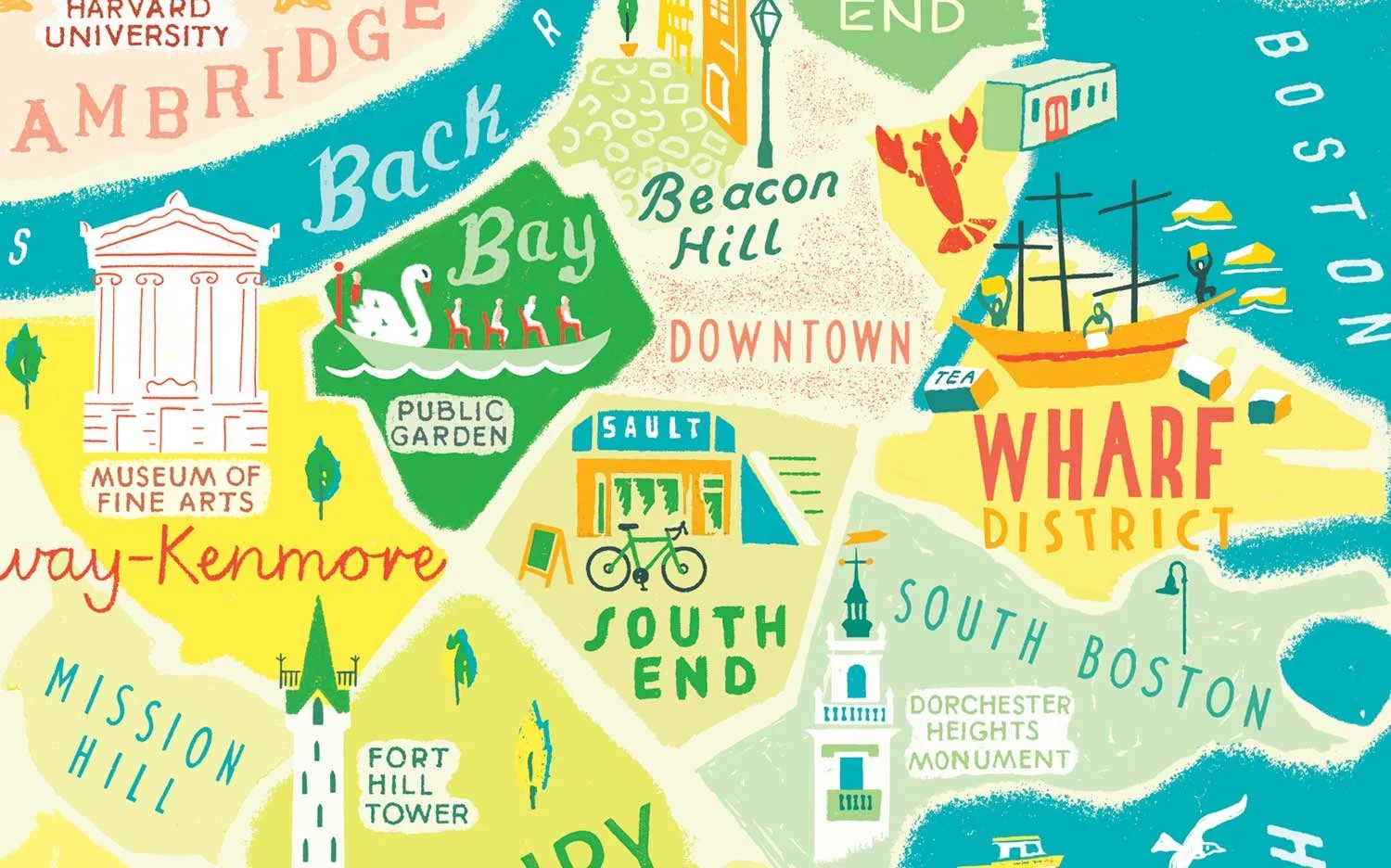
A Boston city map combining detailed neighbourhood landmarks with playful hand-drawn lettering, a colourful example of what custom map illustration can say and do. View full project
What makes an illustrated map different?
A custom map illustration helps people understand a place, follow a route, or explore information visually. Unlike a standard map, it can combine wayfinding, storytelling, landmarks, hand lettering, and brand personality into a single piece of communication.
In my work, I use these elements to create maps that are both useful and engaging to explore. My role is to find the right combination for the audience while expressing the character and identity of a place.
-
![Boston]()
A map can explain relationships, not just locations
I look at how places connect to one another and build visual hierarchy around those relationships, helping readers understand an area quickly.
-
![NCL]()
Information can become part of the illustration
Facts, routes, and practical information don't have to sit outside a map. They can be woven into the artwork so people discover them naturally as they explore.
-
![reek]()
Maps can communicate atmosphere
Illustration allows me to emphasise the character of a place as well as its geography, helping readers form an impression before they begin reading the article.


Every map tells a story! Here are a few of mine
Each project was shaped by what the client needed and where it would be used
Itinerary Maps
I create bespoke itinerary maps that transform journeys, routes, and experiences into clear, engaging visuals. Each map is designed to guide audiences, highlight key locations, and communicate information effectively - whether for travel, events, or storytelling projects.

When information is woven into a map, people absorb it almost without noticing - navigating visually, discovering details as they go, rather than reading a list.
Alaskan Cruise Itinerary Map
I illustrated an itinerary map for cruise line marketing, designed to guide passengers through Alaska’s ports of call. This project combined travel information design with engaging visual storytelling, creating a map that is both functional and memorable. Hand lettered fun facts add character and highlight the unique details of each location.

Tour de France Route Map
I designed this illustrated itinerary map of the famous cycling competition route, showing each stage in detail and including a flight path illustration for the transfer from Bern to Paris. This multi-leg route map guides audiences through the full race, combining technical route information with clear visual storytelling.