
Custom Map Illustration for Organisations and Publishers
I create custom illustrated maps for organisations and publishers to clarify complex location-based information for publications and campaigns, so your audience can understand it quickly and use it confidently.
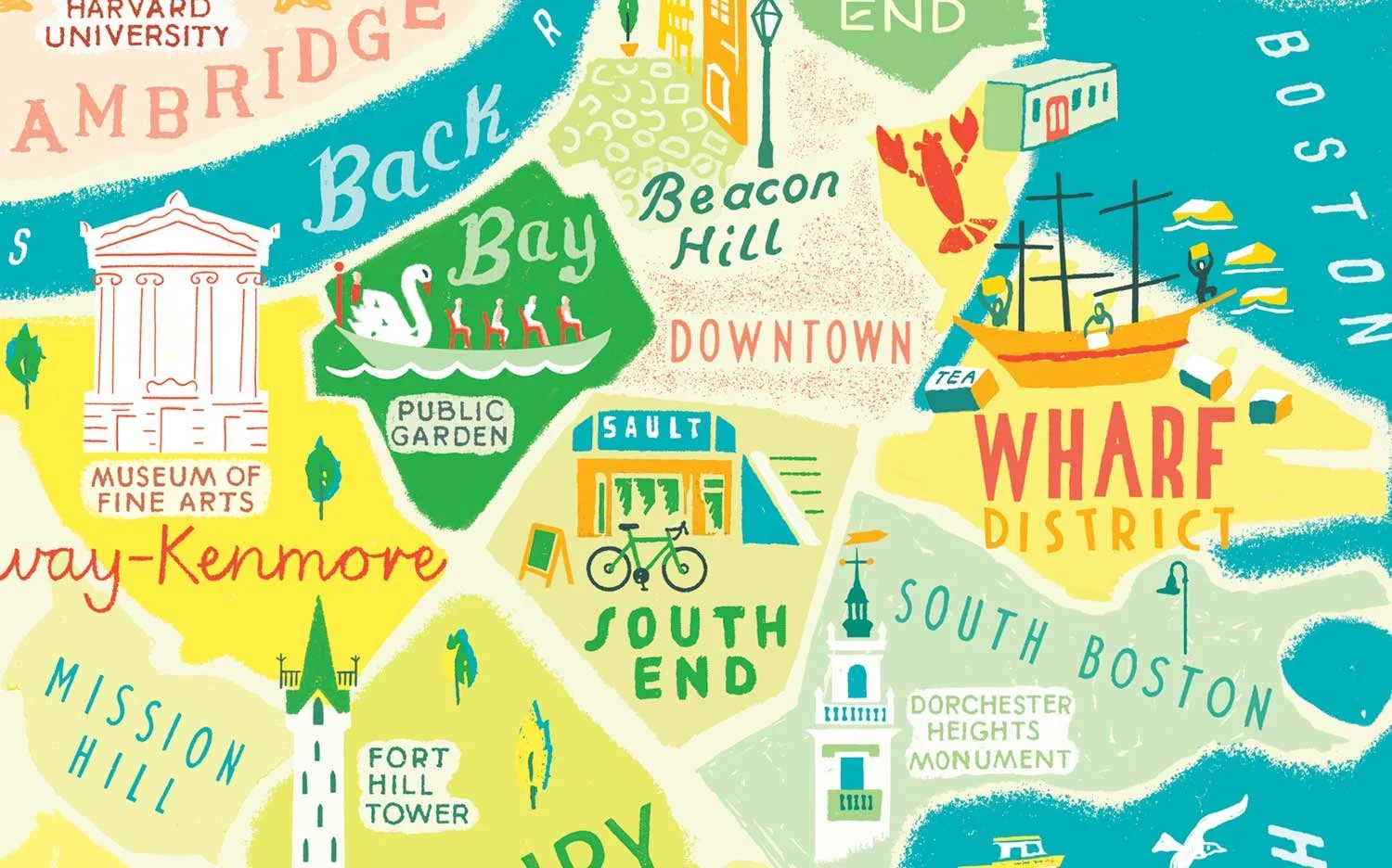
A Boston city map combining detailed neighbourhood landmarks with playful hand-drawn lettering, a colourful example of what custom map illustration can say and do. View full project
Every map tells a story! Here are a few of mine
Each project was shaped by what the client needed and where it would be used
Itinerary Maps
I create bespoke itinerary maps that transform journeys, routes, and experiences into clear, engaging visuals. Each map is designed to guide audiences, highlight key locations, and communicate information effectively - whether for travel, events, or storytelling projects.

When information is woven into a map, people absorb it almost without noticing - navigating visually, discovering details as they go, rather than reading a list.
Alaskan Cruise Itinerary Map
I illustrated an itinerary map for cruise line marketing, designed to guide passengers through Alaska’s ports of call. This project combined travel information design with engaging visual storytelling, creating a map that is both functional and memorable. Hand lettered fun facts add character and highlight the unique details of each location.

Tour de France Route Map
I designed this illustrated itinerary map of the famous cycling competition route, showing each stage in detail and including a flight path illustration for the transfer from Bern to Paris. This multi-leg route map guides audiences through the full race, combining technical route information with clear visual storytelling.

Bobbi the Wonder Dog - Narrative Journey Map for a Children’s Story
I made this illustrated journey map for a children’s story, visualising the true story of Bobbi the Wonder Dog’s long-distance adventure across America. The map transforms a narrative journey into a clear and engaging visual, combining wayfinding illustration, storytelling, and playful iconography to help readers follow his incredible trek home.
This map lets young readers trace Bobbi’s journey from Indiana to Oregon, following illustrated landmarks and landscapes along the way - showing the story visually instead of just telling it.
Maps that bring places to life
-
Guide visitors with clarity
-
Inspire exploration
-
Maps that bring places to life - Guide visitors with clarity - Inspire exploration -
Editorial Map Illustration
I create editorial map illustrations that turn articles into scenes you can explore. My maps help your audience see where things are, follow a journey, and feel the story of a place. They’re designed to support and enrich magazine features and city guides, so readers don’t just read about a place - they can explore it through the illustration.
Feature Map Illustration for Travel Magazines
I’ve contributed editorial map illustrations to NGT UK over several years, adapting my approach to express the character and atmosphere of each new location.
I illustrate immersive city maps, narrative route maps, and feature article maps - blending storytelling, clear visual hierarchy, and engaging layouts to suggest a sense of place and catch attention before any words are read.
Each map starts with problem-solving - finding the clearest, most engaging way to guide people through a place or story, whether it’s a compact city guide, a scenic route, or an immersive illustration.

Full-page magazine layout featuring a custom map illustration from a city map series. I interpreted the author’s description of a ‘tiny’, ‘otherworldly’ city using a bird’s-eye view, making streets, buildings, and surrounding nature feel within reach and helping readers explore key locations visually.

Full-page layout with an illustration of Kuala Lumpur, adapted and expanded from an earlier editorial city map commission. I added hand lettering, numbering, and extra detail to guide readers through shops and landmarks, making the city fun and easy to explore.
Destination and Retail Guide Map Illustration
I create illustrated maps for in-flight magazines and travel guides, combining clear orientation, visual storytelling, and practical information to help travellers explore destinations and retail highlights. These maps allow readers to use the guides easily while they’re on the move or planning exploration, making them both useful and memorable.
Seasonal and Thematic Feature Illustration
I create illustrated maps for travel features where the tone and mood matter as much as the geography. These projects often build a sense of atmosphere around a route or theme - whether it’s a festive city guide, a food trail, or a summer road trip.
Each piece is drawn to work smoothly within a magazine layout, balancing information with storytelling so readers can picture themselves there.

A double-page magazine spread featuring my winter-themed illustration, highlighting local sights and temporary seasonal locations, such as Christmas markets. The illustration adds atmosphere and helps readers connect emotionally with the destination, beyond what photographs alone can convey.
See more editorial map illustrations for magazines, including travel, subscription, alumni, and lifestyle publications here


“Working with Anna was a dream, she always understood the brand and the brief, and produced carefully considered and beautifully illustrated work every issue. Her artwork was not only impactful enough to provide a beautiful visual introduction to the feature, but was also an informative reference map. I've got a real passion for Anna's handwritten type, too. I'm always looking for excuses to work with her again!”
Lauren Atkinson-Smith – Deputy Art Director, National Geographic Traveller UK
City and street-plan maps
-
Hand-drawn maps for walking trails and urban exploration
-
Illustrated guides for tourism and heritage
-
City and street-plan maps - Hand-drawn maps for walking trails and urban exploration - Illustrated guides for tourism and heritage -
Wayfinding and Venue Maps
I create wayfinding and venue maps that help people understand busy or complex places fast. Whether it’s a museum, a city venue, or a sprawling event site, these maps mix clear layouts with character - so everything is easy to spot while keeping it fun to use. They help your visitors feel confident exploring and make sure they remember the journey.

Manchester & Glasgow - City Venue Map Illustration
I illustrated maps for major annual gatherings in Manchester and Glasgow. The maps highlight all the key museums and venues across the city, making it easy for visitors to see where everything would take place at a glance, creating a handy wayfinding map for the city.
Bright, engaging illustration with a sprinkling of local characters and stories, turning a complex city layout into a map people could navigate effortlessly and enjoyably.

Colourful, detailed illustration highlighting the city’s key museums and venues, designed to make the layout approachable, memorable, and easy to explore at a glance.
Edinburgh – Textiles Fair & Self-Guided Walking Map
I illustrated a map for the Selvedge Fair in Edinburgh. It shows the main venue and selected artistic and cultural highlights, with a curated self-guided walking route for visitors who want to explore more.
The map helps visitors navigate the fair and city easily, follow the route, spot key locations, and enjoy an experience that feels well planned and considered.
Cropped detail of the icon-style map showing the curated walking route with numbered key locations. Colourful, detailed vignettes float around it, making the route easy to follow and the information simple to take in.
Commissioned by publishers, travel brands, and cultural institutions
-
Maps that inform, engage, and delight
-
Designed to support your story and audience needs
-
Commissioned by publishers, travel brands, and cultural institutions - Maps that inform, engage, and delight - Designed to support your story and audience needs -
Listing Maps
I create illustrated “What’s On” maps to show audiences what’s happening - and help them notice it in time to join in.
Whether it’s events, exhibitions, or activities, these maps make everything easy to find: on-site, at a venue, across a region, or even nationally.
They offer a flexible visual format for your listings, letting you include routes, times, dates, or any details you need.
Engaging illustration grabs attention early and makes information easy to take in - helping your audience spot what’s coming up and plan their visit at a glance.
Visit this project in full here
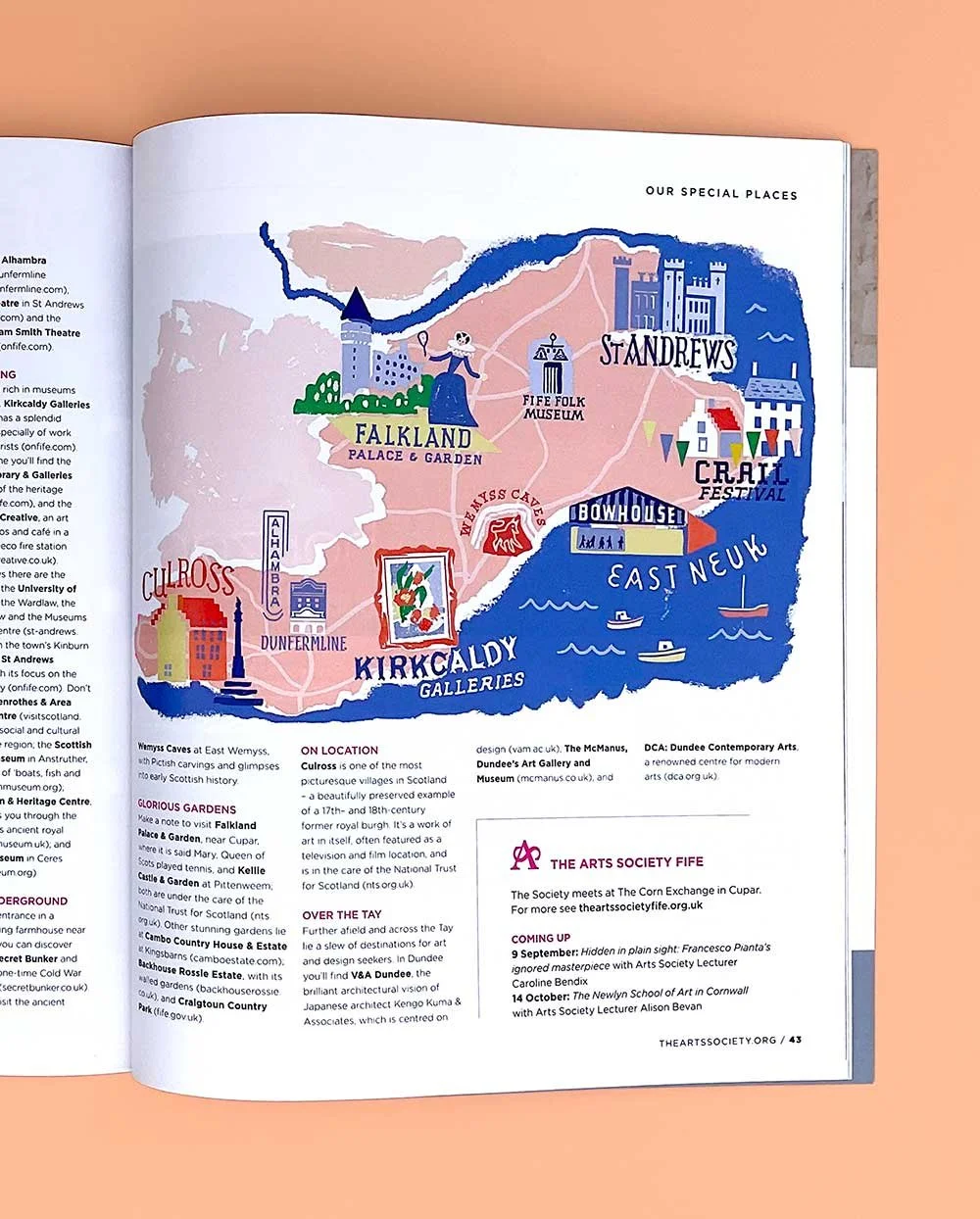
Custom illustrated maps like this regional arts guide for Fife are a clear, engaging way to let people know what’s on - and help them plan their visit.
Hospitality and Lifestyle Maps
I create illustrated maps for boutique hotels, lifestyle brands, and resorts - giving guests a sense of place across welcome materials, printed guides, and branded assets.

Tourism and Destination Maps
I make custom illustrated maps for tourism boards, destination campaigns, and visitor guides - helping audiences picture the places they want to go.

Frequently asked questions
How much does a custom map illustration cost?
The cost is based on how much time and production input your map requires, plus how and where it will be used. Every quote includes a defined scope, licensing terms, and a realistic schedule.
You receive a fully custom map based on an agreed scope, with structured revisions and final files prepared for print or digital use. Costs and licensing are set upfront so there are no surprises. NDA arrangements are available if required.
What’s included when we commission a map from you?
How long does it take to get a custom map?
Most projects take 2–4 weeks from agreed scope. Final timing depends on complexity and approval stages. Share your deadline early and I’ll confirm what’s realistic.
Are revisions included in the cost?
Yes. Every project includes structured development stages, with a minimum of two revision points built-in. The early draft stage allows us to confirm direction before final artwork is completed. These revisions are for refining the agreed brief. Any new additions or changes outside the original scope are quoted separately before proceeding.
Can you design the map to match our brand style?
Yes. Each map is developed to reflect your brand’s palette, tone, and visual language. The layout and hierarchy are designed to communicate clearly while staying consistent with your existing materials. This is the advantage of commissioning a custom map rather than using stock artwork.
Will the map work in print and online?
Yes. Files are prepared for the agreed use, so they’re ready for print or digital without needing to be fixed or converted by your team. If you later need another version, just let me know.
Best for:
Organisations and publishers commissioning custom illustrated maps to clarify location-based information
Maps used in reports, publications, campaigns, and websites where clarity and hierarchy matter
Projects where the map needs to help an audience understand quickly and use information confidently
Less suitable for:
Private/personal commissions (weddings, gifts, family maps)
Generic, ready-made map requests
Turnarounds under a week
Commission a custom illustrated map
If you’re planning a publication or campaign and need a clear, purpose-led map, feel free to get in touch with an outline of your project.